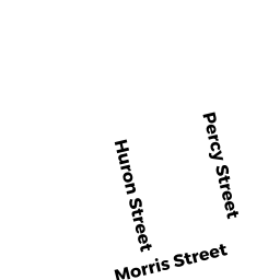
110 PERCY ST
Owner Information
MAO AKARA V. (TE)
110 PERCY ST
DRACUT, MA 01826


Property Details
110 PERCY ST is classified as a Single Family Residential (Ranch).
The primary structure on this property was built in 1950. There are 3,588ft2 of built area within this property. There is 1,475ft2 of residential/living space within this property. This property is listed as having 60 rooms.
110 PERCY ST is valued at $360,100. The land is valued at $156,600 and the structures are valued at $199,000. There is an additional valuation of $4,500 on this property.
This property is in Zone R3. Confirm with local Zoning Board authorities to ensure there are no overlays or other easements on this property.
The most recent deed for 110 PERCY ST is recorded at the local registrar in Book 21469, Page 0214. 110 PERCY ST was last sold on Tuesday, July 31, 2007 for $280,000.
Assessment data from fiscal year 2022.
Flood Data
According to the FEMA National Flood Hazard Layer, this property does not appear to be in a flood zone. It may also be in an area not yet reviewed. Nonetheless, confirm this information prior to taking any action.
To view the flood hazards around this property, create a FEMA "Firmette" Map of the area around 110 PERCY ST.
Broadband Internet Providers
| Provider | Type | Bandwidth (mbps) | |
|---|---|---|---|
| T-Mobile | Fixed Wireless | 25 | 3 |
| VSAT Systems, LLC. | Satellite | 2 | 1 |
| HughesNet | Satellite | 25 | 3 |
| GCI Communication Corp. | Satellite | 0 | 0 |
| Comcast | Cable | 1000 | 35 |
| Verizon New England Inc. | DSL | 1 | 0 |
| Viasat Inc | Satellite | 100 | 3 |
Broadband service provider data from December 2020.
Adjacent Properties
- 891 METHUEN ST
Day Care Centers, Adult (see also Code 140) owned by IDI MANAGEMENT, LLC - 95 HURON ST
Single Family Residential owned by ROMANOWSKI KAREN E. - 87 HURON ST
Single Family Residential owned by MARKHAM DAVID P (TE) - 88 PERCY ST
Single Family Residential owned by BESTOR DAVID A. - 112 PERCY ST
Single Family Residential owned by PAUL CHRISTOPHER A. ( TE)